Sunday, October 6, 2013

Mile-2660 Manning Park to the Monument

We made it! We hiked to the PCT monument at the border, the symbol of the end of the journey. If you want to read our PCT story chronologically, see right menu and start March 2013...

The Last Day

We waited till Lighthouse arrived from Vancouver and then the three of us had a very pleasant hike, reminiscing, philosophizing, and sharing stories, to the monument. 
When we got there we saw Toots, Cuddles, Atlas, Rafiki and the Chosen One, the only one to have made it via the PCT. Tracy got the scoopage from him: breaking trail, post holing, teeth chattering, barely able to swallow pop tart, grizzly bear footprints, fear. There was a nice guy there who is making a film about the Chosen One's journey who waited for him to arrive and filmed a few shots while we were there. Can't wait to see the film: A Single Step. 
We took lots of photos, lingering till it got too cold, then hiked the 8 miles back to Manning Park. There we changed into our street clothes, I applied mascara, and we walked into real life...
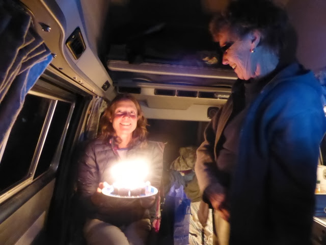
We're spending a few days with Karen, Tracy's mom as we make our way back to Seattle in her camper. Meanwhile, the Facebook Class of 2013 site is buzzing with activity as people post finishing photos. Tracy and I have had lots of Facebook friend requests from hikers as they sit at home going through photos and try to keep contact with the trail. I'm sure we'll do the same. It will be hard to let go. What an epic journey we've had. The trail was at times dull, spectacular, magnificent, pretty, austere, treacherous and ever changing. The people, well they are up there with the High Sierras, they made the journey memorable. 
Good news. Today they found Rocket Llama the 23 yr old female hiker that had been missing. Phew!
Once we get back to Seattle I will upload all our pictures and give a little final update. Tracy might also post about the gear we used. So keep tuned. 
Lots of love to all of you who have been following our steps. Thank you. 💐


Friday, October 4, 2013

Mile 2600 Winthrop to Manning Park, CA

What a day of decisions and indecision. As soon as I got up I spread out the new maps on the kitchen table and taped them together, grabbed a cup of tea and started to check out our new route. That's when I noticed that our low altitude escape route into Canada at Monument 83 was actually 6500 ft.  Oops! No one else we knew was taking this route so we might have to break trail though the snow. Not good. Then Adam, who worked at the hostel and who has done a lot of climbing in the area came over to look at the map. He wasn't sure that the most northernly trail that connects to the PCT even existed anymore. He said he'd call a friend. The friend said the trail exists but at Frosty Pass, over 6000 ft there are two avalanche chutes etc. and we'd be breaking trail. We'd also be on our own with no one in front or behind us and no PCT app that tells us where we are on trail (or not). 

So that route is a no no. The Ross lake route is a no no because of park closure. This made the PCT start to look like the safest option. Tracy posted a note on the Class is 2013 Facebook page asking if anyone had actually completed the section from Harts Pass to the border in the last few days. Meanwhile we went to the outdoor store to check out snowshoes, boots and winter gear. In there we met Rafiki, a hiker we know from Alaska who'd just come off trail at Harts Pass and was returning snow shoes. She said the snow was beautiful, but that there were already signs of unstable snow and she felt unsafe without an ice axe. The current snow is melting and will turn to ice at night so the next dump of snow will set up dangerous avalanche conditions. According to the forecast the next snow is Sunday evening. This is Friday. There are only 38 miles from Harts Pass to Manning Park, Canada, but we're unsure how many miles a day we can do on snow.  Dilemma Rama! What to do?!

The worst part of this decision making was that it was gloriously sunny today. We need just 3 days to safely get through the next section but we only have a 2 day window of sun. If we'd been able to leave this morning we'd be okay. Timing! Timing. 

After much deliberation we went for SAFETY first. :(  Talking of safety, one of the Japanese hikers who had gone missing was safely rescued by helicopter this morning. Another hiker who has been missing for 5 days near the goat rock area has not been found, PCT hikers have been asked to help in a ground search. 

I'd also like to point out that although my brother encouraged us to go on, (see previous blog entry) saying gingers wouldn't let a wee bit of snow discourage them, he later confessed that in the face of danger our survival may also have included holding back and letting people with dark hair go in front. :)

So, once the FedEx package with my visa extension arrived we got in the camper and drove up to Manning Park. Tomorrow we'll hike southbound to the PCT monument at the border. 


Mile 2600 Winthrop

Before we made any decisions about our next steps, we wanted to check the weather and buy a few maps. Also, my Tourist visa extension approval letter had just arrived at Beth and Mary's in Seattle. I need this to get back in to the states. So we asked Mary to have it fedexed overnight. Though the weather is great today, we can't go anywhere till the visa arrives tomorrow before 5pm. 

Meanwhile, Tracy's mom was only 20 miles away, making her way slowly up to Canada to meet us. Tracy called her last night so we could spend time with her during the wait. She would also drive us up to Canada or to the trailhead, depending on our decision. 

After she arrived we had a nice marionberry cobbler and latte at the local bakery. After that it was pretty much business. We ran in to Otter our temporary roommate in Mammoth. He's hiked parts of this last section many times. He is considering taking a lower elevation route along the west fork of the Pasayten River. This route is longer, widely paralleling the PCT to the east but would avoid much of the deep snow. There is also possibility to connect with the PCT at three points. If we connected at the last point, we'd just have one 6,000 pass to get over and then be able to come out at the PCT monument. If this route is iffy, we we would just turn back and go into Canada at monument 58 further east. 

So, we upgraded from plastic bags to neoprene socks and Mammut waterproof mittens. Bought maps and new compass. Oh, and this route does not go through a national park, but a national forest, so it should be open and unguarded by rangers. By the way, Diane at the outdoor store was extremely helpful and gave us a lot of guidance regarding our hike. 

We all stayed in the hostel but Karen (Tracy's mom) cooked us dinner in her cozy camper as Tracy and I had a couple of beers and talked trail. We also had a little belated-birthday cupcake celebration for Tracy. 


Wednesday, October 2, 2013

Mile 2580-2600 High Point camp to Winthrop via Rainy Pass HW 20

It felt great to wake up in our manger and pack up our dry things, and have breakfast while it the rain gently spit outside. The trail today followed a creek all the way to Rainy Pass 20 miles away. It rained all day. My foot bagging experiment failed. I had a sock then baggie on my right foot, and a baggie on foot, sock, baggie on top combo on the other. After a couple of hours both feet were drenched. I'd made holes in the bags with my firm yet girlish stride. Tracy hasn't put any holes in hers yet her feet were soaked too. It was freezing. The first day I've ever felt comfortable wearing   3 layers on top. Not much to look at because of the grey,mist and rain. And then it got very pretty indeed, it began to snow. Large sticky snowflakes that landed on christmas trees and whitened everything around us. 
When we got to the pass an emergency back up plan, if we were desperate and needed dry shelter, would have been to camp in the toilets. They were shut as part of the government closure, with a note about being closed for safety reasons. We had already decided that it made no sense to camp and get wet when we could hitch to Mazama or Winthrop and continue the trail tomorrow. We stood out on the snowy highway and got a ride within a couple of minutes from a lovely couple, Ben and Judy from Linden, Washington. They were going to a family cabin past Winthrop so offered to drop us off there. They took us right to the hostel there. 

Drama! We met a lot of hikers who had hiked north of Rainy Pass but had to turn back because of post holing through waist high snow. It was taking several hours to get through a mile of trail. Some of those hikers then tried to get to Canada via an alternative trail at lower altitude via Ross Lake. But they were turned back at the trail head by Rangers. The trail is on park property and is therefore officially closed. Apparently the rangers are trying to get everyone out. These hikers were given warnings. Everyone here is now off the trail. Many have been crying. Most are leaving for home but a few people are driving up to Canada to walk south to the border and monument to symbolically complete the journey. 

Our plan earlier this evening was to take the lower alternative route, but as T has pointed out I'm here on a tourist visa and I shouldn't jeopardize this by breaking federal law. 

Lets see what tomorrow brings. Im hoping for Sunshine and and an up and running federal government.


Monday, September 30, 2013

Mile 2580 Chelan via Stehekin to High Point camp

As if the snow on the mountains ahead wasn't enough to deal with, the US Federal government is having a shut down. It was only when we were being driven to the ferry, by Karen at the Apple Inn Motel for the 8:30am ferry to Stehekin, that she mentioned that the parks shuttle bus to the trailhead 18 miles away may not be running. This would change everything. We wouldn't take the ferry but hitch to another trail access point instead. We had a dramatic 20 minutes, while Karen waits for us, as we tried to get more information. Tracy called the Stehekin Lodge's satellite phone only to find out they open at 8:30, the same time as the ferry leaves, and we needed to decide whether to be on it or not. Meanwhile I ran over to the float plane office, which also acts as a booking office for the lodge, to see if they  knew about the shuttle buses. The woman there told me that 'the woman who knows everything starts at 8:30'. We decided to take a chance and got on the boat. Just after we boarded we got confirmation that the buses will be running for at least 48 hrs. Phew!

The ferry was very relaxing, we did the NY Times crossword and actually saw our surroundings on this trip back up Lake Chelan as the weather was good. When we arrived at Stehekin we talked to hikers who were leaving the trail. Muk Muk and UB however were both continuing. We were excited that we had found others who were still gung ho about continuing. I shared my brothers message of support with them:

That's the spirit Ing .  We are from Scotland remember.  If we couldn't handle a wee bit rain n snow, we ginger folk would have died out millennia ago.  
But..

we Didnae! 😠

We hung out for a while then decided not  to stay overnight, as Muk Muk had offered, but to take advantage of the good weather and take the bus to the trailhead. When we got to the trailhead we left a note on the notice board for hikers coming in from the trail. We let them know that due to govmt shut downs as of Thursday afternoon the lodge, restaurant, store, shuttle bus and ferry would be closed down but the post office remains open. 

And then it started to rain. Fortunately we found a fantastic shelter at the campsite near the trailhead. The kind of shelter we have dreamt of the entire journey. A solid open log structure with a grand smell of horse manure, which neither of us mind. Smells a lot better than most hikers. It was infact a kind of manger, with straw on the floor. Little baby Jesus would not have looked out of place here. Tracy lit a candle and made little night tables and benches with logs. Cosy, cosy and we didn't have to use our tent, keeping it nice and dry. 


Mile 2580 Chelan

Oh dear, after looking at the weather reports it seemed to us that the best plan  was to wait in Chelan, dry, warm, relaxing and eating as much as possible, until the weather improved. We had fun hot tubbing and going for beers with Slosh, Smiles, TRex and Rocky. Also bought more food for the next last push in case we have to wait out a storm in our tents. Plus we got mini garbage bags to use on our feet. Experimented today by wearing one on my left foot. Scientific Result: right sock dry, left sock a little damp but not saturated from sweat. 

We leave tomorrow, Tuesday, and will take the 4 hour ferry back up to Stehekin and get back on the trail around 3pm. If all goes to plan, we should arrive in Manning Park, Canada by Saturday. 


Mile 2571-2580 Cedar camp to Chelan via Stehekin

Rain, rain, rain. We heard Shredder leaving at 4:30am so that he'd make the 9am shuttle bus to Stehekin. We got up at 7am, packed up our soaking wet tent and hiked the 9 miles to High Point and waited for the 12:30 bus. There's no shelter at the bus stop so we made videos under our umbrellas to keep warm. I'll eventually update the photo and video sections once we finish the trip.

The bus finally arrived and the first stop is a bakery! Guess who came out of the bakery? Smiles and Slosh our first trail friends. Fifty dollars of bakery goods later, T and I sat on the bus and caught up with them and other hikers. 

We arrived at Stehekin landing and confirmed there was no internet or cell reception. Lots of hikers were leaving the trail, the rain and snow reports were not good and there was a rumour that the northern part of the PCT had been closed. We decided we needed to find our for ourselves. So we got on the 2pm ferry down Lake Chelan and booked into the Apple Inn Motel along with Smiles, Slosh, TRex and Rocky where we checked weather reports and formulated a plan. 


Mile 2541-2571 Dolly Vista Trail Camp to Cedar Camp

Epic day!

Woke up to snow falling. We had 29 miles to get to High Point where there's a shuttle bus to Stehekin. In this terrain we knew we couldn't get there by tonight, but if we pushed it, it might be possible to get there for the 9am bus tomorrow. That way we'd get there before the post office closed on Sat morning, pick up our resupply box and not have to wait till Monday for it. Challenge! Fun! Snow!

Our concern was getting over the high pass in the snow, but first we had a decision. Take the new PCT trail and go over a bridge, which adds an additional 4.8 miles, or take the old, non-maintained PCT route and hope that the scary log crossing is still there. No competition, the log crossing it is. 

This section has been the most isolated and wild we've encountered, there are no fire roads or service roads so it must be very difficult to maintain the trail. The old PCT route was even more wild. There were huge knocked-over trees crossing the trail, wash outs and overgrown sections which made the trail like an obstacle course. Awesome! No need for podcasts today. We were both fully engaged in the trail, ducking, climbing, jumping, only stopping to ring out our gloves. It rained all day. 

When we got to the infamous log river crossing Tracy and I followed the cairns upstream and I saw part of the large log. But then we heard people shouting at us from across the river downstream. We walked the quarter mile back downstream and found out they wanted to tell us hikers that they had successfully crossed at another log even further down river. This was turning into a rather long shortcut, however we all (Frosty, Goldilocks, Shredder and Tracy) crossed the log using various styles and methods and finally found the trail on the other side. 

The pass wasn't a problem but we decided not to race to make the post office as Tracy had bad cramps in one of her legs and had to slow down and didnt want to make things worse. (We eventually remembered, thanks to my dad, to take salt. She said her leg improved by 80% almost immediately.) We also didnt want to walk in the dark. Just as we were approaching camp in the half light we spotted Cherub, our South African hiking buddy. She had fallen in the river when using a rope and was drenched. Fortunately her sleeping bag was protected. She wanted to make the post office too and was planning to hike in the dark till 9pm. Such a trooper! I asked if she'd cried after she got soaked.  "No, my feet are dry, I have waterproof socks." She also took Tracy's drivers license and offered to pick up our package for us. Meeting people like Cherub, Bebo and Sharky, and Booboo Kitty who demonstrate such strength of character has been one of the highlights of the trail.